VLAAMS INSTITUUT VOOR DE ZEE
PLATFORM VOOR MARIEN ONDERZOEK

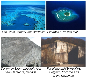 |
The Devonian (416 - 359 million years ago) was a period of widespread reef growth. Reefs can have very diverse geometries and morphologies, and can be built up by a diversity of processes. Existing types include reef banks, giant barrier reefs, isolated atolls but also reef mounds (hill-like structures) or lime mud build-ups (a.k.a. mud mounds). Impressive reef examples are known from all over the world (see pictures). The Kess-Kess mounds that will be studied in Class@Desert are hill-shaped structures containing large amounts of lime mud. |
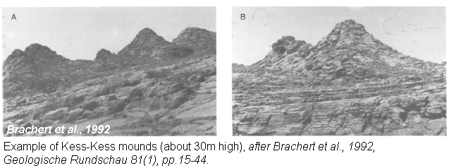
The Kess-Kess mounds are situated in the eastern Anti-Atlas of southern Morocco, near the border of Algeria. They are situated 16 km south-east of the city of Erfoud. A large ridge structure, known as the Hamar Laghdad Range, extends for about 8 km in an east-west direction and it is about 1.2 km wide. In the central and eastern part of this Hamar Laghdad Range, we find the Kess-Kess mounds. All 48 mounds occur in a small area of 0.5 by 3.5 km.

The name 'Kess-Kess' refers to the conical shape of the mounds which resembles the dishes that are used to cook the Moroccan national food cous-cous. Three distinct morphological types of build-ups are found: mounds, pinnacles and multicored complexes. 1) Mounds are lens-shaped, on average 40 m long, 30 m wide and 65 m high. 2) Pinnacles are conical, have width to height ratios of about 2:1 and are average 65 m long, 55 m wide and 30 m high. 3) Complexes vary considerably in shape and are up to 510 m long, 85 m wide and 50 m high. They consist of a number of individual mound cores that started growing at different stratigraphic horizons.
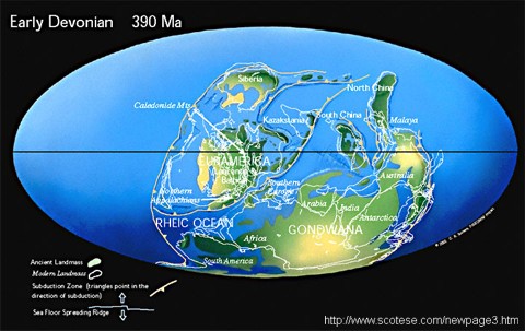
During much of the Paleozoic (542-251 million years ago), the eastern Anti-Atlas area was a broad shelf, so it was flooded by the sea. During the Early Devonian (416 - 398 million years ago) the Kess-Kess mounds were forming in a region about 40° S. This is comparable to the present day position of the most southern part of Chili. The mounds occurred in deep waters, below fair weather wave base, but within the range of major storm generated wave. This explains why under normal conditions, much mud could accumulate.
The actual genesis of the mounds is still a matter of debate! A number hypothesis have been postulated over the years. An overview of the different theories is given below.
The mounds stopped growing when the sea-level was at its highest point. The mounds are covered by a slowly deposited thin sediment bed ('a condensed bed') and are thereby separated by the overlying deposits. The exact cause of their dying is still uncertain, however evidence indicate that the mounds were drowned and remained virtually uncovered for a very long time. In the Kess-Kess mounds, extremely much fossils are found, including crinoids (sea lilies, family of the seastars and sea urchins), trilobites (now extinct), tentaculitids, brachiopods (still exists today), corals, gastropods, ... The fossils from these area are often exceptionally well preserved and are world famous. The question in which way these animals have controlled the mound development by construction, binding, baffling, and destruction, is crucial. If we can find out how the building process took place, we might actually better understand the present-day underwater coral mounds. | 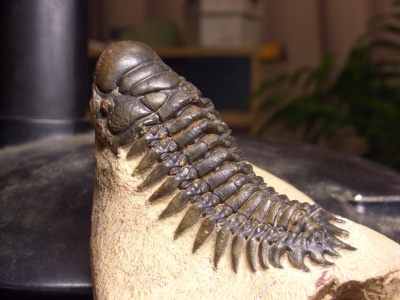 Example of a trilobite |
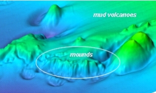 Bathymetric image of the Pen Duick Escarpment (Moroccan Margin), a cliff with small mounds on top. The larger conical structure are mud volcanoes. |
The Early Devonian mud mounds described above may be an analogue of the modern build-ups discovered in the deep Atlantic waters off western Ireland and in the Gulf of Cadiz (between Spain and Morocco, west of Gibraltar). The dynamics of these recent mounds are subject of thorough investigation at the Renard Centre of Marine Geology (RCMG) in Ghent. During the field expedition, we are able to compare the present-day offshore mounds with the fossil ones in the desert of Morocco. |
The famous geologist Charles Lyell once stated that "the present is the key to the past". The purpose of this expedition is to use our knowledge of the recent mounds as a key to the Early Devonion mounds in Morocco to get a getter understanding in their genesis, growth and death.