Quirimbas - Mnazi Bay ComplexLocation / General description / Features of Potential Outstanding Universal Values / Threats / Management status / Geographic scale, integrity and site type / Other sites in the region / Key References
Location – The Quirimbas archipelago is a string of coastal islands extending from Pemba Bay in northern Mozambique, 400 km to the Ruvuma estuary and the Mtwara-Mnazi Bay reef system in southern Tanzania. A series of submarine canyons continue farther south in Mozambique, to approximately Nacala in Nampula province, and we use this to define this region where submarine canyons, deep sheltered bays and coastal islands interact with the South Equatorial Current (SEC) and eddies of the northern Mozambique channel. General description – This complex is located in the center of the East Africa Marine Ecoregion (EAME) of the WIO where the South Equatorial Current (SEC) and unique oceanographic features of the Mozambique channel meet the mainland African coast. At the northern end of this region, the EACC flows north throughout the year, forming a one-way conveyor for marine larvae dispersed northwards to Tanzania and Kenya. At the southern end of this region, upwelling and the Zambezi delta system influence marine habitats, and past the constriction in the channel at 17°S flow is predominantly southwards. Between these two points, clockwise and anticlockwise eddies may push water in any direction, and the consistent marine climate results in the highest diversity in coral reef species west of the Andaman islands in the Indian Ocean. Geologically, the site is in the East Karroo Rift System, composed primarily of old sedimentary deposits from the Jurassic and Lower Cretaceous. The sedimentary layers are eroded in places, such as Mnazi and Pemba Bays, with additional structure provided by past reef growth that forms the reefs and islands along the coastline. The continental shelf is very narrow, off Mnazi Bay being only about 1-3 km wide. Deep canyons are carved in the continental slope at some locations, such as Pemba Bay, which continue southwards in Nampula province, such as at Nacala. The Quirimbas Archipelago comprises some 28 islands and the offshore Lazarus Bank. The archipelago has the highest diversity of corals recorded in the WIO (along with northern Mozambique), with almost 300 species in 60 genera. The region has important marine and terrestrial habitats, including coral reefs, mangroves, miombo woodland, acacia savannah, coastal thicket and tropical dry forest and woodland. Charismatic species include turtles, dugongs and elephants, and many rare and endemic plant species. Three species of marine turtles are known to feed and nest in the region, namely the olive ridley and green, with high abundance off Ibo island, and hawksbills off Quilalea and Sencar. Dugong are known to reside in the Quirimbas National Park area, but are scarce and their actual numbers unknown. Dolphins, whales (namely the humback whale), sharks including bull shark, white tip shark, whale sharks and large populations of manta rays are known to frequent the islands. The Quirimbas National Park protects a portion of the south-central part of the archipelago and mainland, including approximately 6,000 km2 of mainland and 1,500 km2 of marine and island habitats. Eleven coral islands lying close offshore and stretching for 100 km along the coast, are included in the Park. In the north, consortia comprising villages and private operators have established protected zones around Vamizi and Metundo Islands. The Mnazi bay is enclosed by sandy shores to the west and the Ruvula-Msimbati spit and string of rock islands and reefs to the east. The bay varies in size from 67 to 150 km2 at low and high tides, respectively, with only one major deep channel, the Ruvula channel in the south. As a result, the channel experiences very high tidal currents (up to 6 knots) creating a complex range of coral reef and other habitats, making it an unusual feature for East African reefs. The distinctness of the Mnazi Bay–Ruvuma Estuary Complex was recognized by the Tanzanian Government for its biodiversity value in 2000, and gazetted as Tanzania’s second marine protected area, the Mnazi Bay – Ruvuma Estuary Marine Park (MBREMP) covering an area 650 km2, of which, 200 km2 is marine, including islands, coral reefs and mangrove forests.
Threats – The region has been remote for many years, with generally low coastal population density, however active migration by fishermen has resulted in high pressures throughout the region. The more densely populated areas, such as around Pemba Bay and Mnazi Bay show severe impacts from overfishing, net dragging, gill netting, dynamiting and illegal and unregulated fishing. Migrant fishing along the coastline poses particular problems of regulation, as incentives to reduce overfishing are low. Around Mnazi Bay, historical dependence on coral mining has led to stripping of shallow reefs of the primary reef building coral, Porites. Climate change has impacted reefs in the region, though with very variable levels of impact, perhaps reflecting complex interactions between the variable eddies and currents, and the complex shoreline of islands, bays and adjacent mangrove ecosystems. Management status – National marine protected areas have been designated at the southern (Quirmbas National Park) and northern (Mnazi Bay – Ruvuma Estuary Marine Park, MBREMP) parts of this region, providing a foundation for trans-boundary initiatives. Further, private initiatives between villages/communities and the private sector are establishing successful reduced- or no-take areas (e.g. Vamizi, Metundo) with benefit-sharing with the local communities. However, successful integration of these efforts, and expanding the area of well-managed parts of the region are needed, and active transboundary initiatives will be needed to deal effectively with growing threats in particular fishing, climate change and mining. Geographic scale, integrity and site type – The complex is unique in the WIO and globally, particularly as it acts as critical node to supplying marine organisms to the East African coast (Kenya, Tanzania, Mozambique and northern South Africa). Either the entire system, or key locations within the region, could form a potential nomination for World Heritage. Other sites in the region – Other sites in the region either have similar (N Madagascar) or lower-diversity communities of similar types as the Quirimbas-Mnazi Bay Complex, however its oceanography and coastline interactions are unique, and biodiversity at the highest level, establishing it as a critical zone for biodiversity conservation.Key References – Garnier et al. (2008); Kelleher et al. (1996); Kemp (2000); McCarthy et al. (1994); Muhando et al. (1999); Obura (2004); Samoilys et al. (2011); Wagner et al. (2004). --> References |
Assessing potential World Heritage marine sites in the Western Indian Ocean |
 Location map
 Coral reefs of the Quirimbas-Mtwara region are among the most diverse and robust in the region, both in the shallows (top, Vamizi island) and on deeper platforms and slopes (bottom, Pemba Bay).
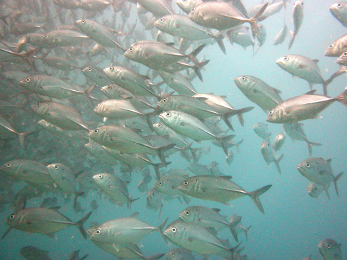
 Fish populations in the Quirimbas islands are less impacted due to their remoteness and rough sea conditions, enabling the survival of larges schools of jacks (Caranx sexfasciatus, top) and large groupers such as this Epinephelus tukula (bottom).
Website developed and maintained by VLIZ
