Methodology
1. INTRODUCTION
2. RESEARCH DESIGN
3. SAMPLING
INTRODUCTION
The research project will adopt a bottom up approach, combined with a literature review of historical fisheries studies focusing on the BPNS. Central to the study is a period of field work during which the ecological knowledge from fishermen (LEK) will be collected by interviews. Apart from the interviews, the preparation of the working instruments, the discussion of the results and the verification of the outcome with other data resources will be vital to this project. Firstly, we will collect and synthesize ecological knowledge from fishermen of fish resources and a changing sea environment during the past 50 years. Secondly, the results of this information will undergo a validation/interpretation process based on comparable scientific ecological knowledge (SEK) provided by the members of the Follow-up Committee and by historical data gathered from the current literature. Thirdly, LEK and SEK results will be discussed with the stakeholders (fishermen, officials from the fisheries administration, fishery scientists). Finally, the evolution of fishery activities in the BPNS will be mapped.
RESEARCH DESIGN
Phase 1: Gap analysis and methodology
- Collecting information from the follow-up committee of SEK main stream data in the BPNS in order to identify the main knowledge gaps.
- Collecting information from fishermen to consider issues important to them.
- LEK-literature study: use of LEK in other countries to learn about the conditions and criteria to use LEK from fishermen. To contact scientific experts to learn from their experience and to discuss problems and issues related to the Belgian context.
- To develop a profound LEK – methodology concerning:
- Development of the questionnaire and the topic list for the interviews. A distinction will be made between the commercial and recreational fisheries. Parallel pre-selecting fishermen for testing will be made.
Phase 2: Test
- Evaluation and discussing the results of the test interviews by means of the follow-up committee and focus groups concerning the questions asked, validity and reliability.
- To refine and improve the topic list and the questionnaires.
Phase 3: Data collection
- Data collection from commercial and recreational fishermen through the use of face to face semi-structured interviews and questionnaires.
- Transcribing and data analysis of the interview results.
- Translating spatial interview information.
Phase 4: Data analysis and accounting
- Data interpretation and validation with members of the follow-up committee.
- Discussing spatial analysis with members of the follow-up committee and with fishermen and validate the data.
- Discussing changes in fisheries and ecology during the last 50 years with fishermen and with members of the follow-up committee and search for explanations.
- Creating maps on commercial and recreational fisheries.
SAMPLING
Belgian Part of the North Sea
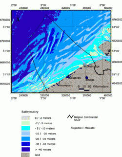
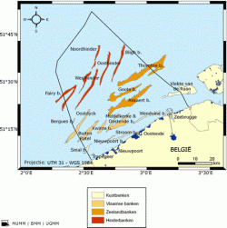
The Belgian Part of the North Sea (BPNS) is the focus of LECOFISH. The surface area of the BPNS is 3600 km2. The overwhelming majority has a depth of 20 to 30 metres. The BPNS consists of sand banks almost parallel next to each other.
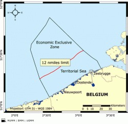
The BPNS comprises several legal zones. The first zone is the Belgian territorial sea which contains 12 nautical miles starting from the coast line. Belgium has sovereignty extending to the air space over the territorial sea, the sea-bed and the subsoil. The contiguous zone is a part of the sea adjacent to the territorial sea, extending 12 nautical miles further, therefore 24 nautical miles from the baseline. The exclusive economic zone (EEZ) goes up to 200 nautical miles from the coast line. The EEZ corresponds to the Belgian Continental shelf that is seen as the natural extension of the country.
Belgium has a fishing zone whose boundaries coincide with the boundaries of the Belgian Continental Shelf. Fisheries are regulated by the European Union on the basis of the annual TAC that is distributed among the EU countries. In addition, there is a set of technical measures for fishing nets and for minimum size or weight of fish landed.
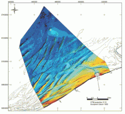
Figuur 1: Bathymetrie
Bron: Management Unit of the North Sea Mathematical Models, Belgian Continental Shelf and bathymetry, Royal Belgian Institute of Natural Science MUMM: http://www.mumm.ac.be/EN/NorthSea/geography.php .

Figuur 2: sandbanks/zandbanken
Bron: Renard Center for Marine Geology, Bathymetrical GIS map, Ghent University.
Figuur 3: sandbanks/zandbanken
Bron: Management Unit of the North Sea Mathematical Models, Zandbanken, Belgian Institute of Natural Science [WWW], MUMM: http://www.mumm.ac.be/NL/Management/Atlas/map.php?Sandbanks.

Figuur 4: legal zones/juridische zones Bron: Management Unit of the North Sea Mathematical Models, The territorial Sea and the Exclusive Economic Zone, Belgian Institute of Natural Science [WWW], MUMM: http://www.mumm.ac.be/EN/Management/Atlas/map.php?TerritorialSeaEEZ .
LEK hold by fishermen
In concrete terms, the objective of LECOFISH is to collect local ecological knowledge relating to fisheries and ecosystem related topics. Consequently, this could be considered as the sampling population. Therefore, LEK is the feature of concern that is widespread by:
- Commercial fishermen
- Recreational fishermen
Within these two general groups, division can be made based on:
- Target species.
- Fishing characteristics e.g. fish methods, engine power, and technology.
- Geographical location, fishing grounds.
- Biophysical and environmental conditions e.g. the seasons, sand banks,
- currents, weather conditions, etc.
- Ways to transfer knowledge e.g. fishing community, formal education,
- observation, family ... .
- Fishing knowledge Network: community, family and friendships.
- …
Timeline
The timeline includes the period 1950 until today.


