The Comoros – Glorieuses crescent
Comoros - Jurisdiction/ - Discription/ - Features of Potential Outstanding Universal Values
Mayotte - Jurisdiction/ - Description/ - Features of Potential Outstanding Universal Values
Threats/ Management status / Key References
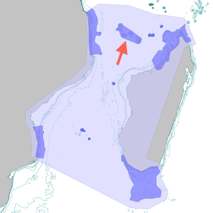 The Comoros-Glorieuses crescent caps the north of the Mozambique channel. This sheet presents the Comoros and Mayotte, while Glorieuses and Geyser are presented under the Iles Eparses The Comoros-Glorieuses crescent caps the north of the Mozambique channel. This sheet presents the Comoros and Mayotte, while Glorieuses and Geyser are presented under the Iles Eparses
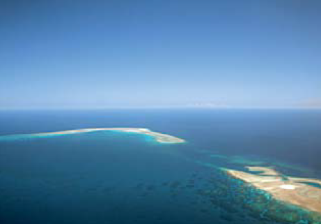
© David Obura
|
Location - The Comoros archipelago consists of four volcanic islands – Ngazidja (Grande Comore), Moheli, Anjouan and Mayotte. These are extended to the east by several emergent (Glorieuses, Geyser) and submerged (Zélée, Leven, Cordelière) reef-banks, which are described in the next section on the “Iles Éparses” of the Mozambique channel.
Geologically, the islands and banks have complex origins. Hypotheses include classic plate movement over the Comoros hotspot over the last 15 my, versus alkaline basaltic magma extrusion along north-west fractures remaining from southward movement of Madagascar relative to the African mainland, periodically active during the Tertiary. The age of the Comorian islands increases from west to east. The formation of Mayotte started with submarine volcanism from 15 to 10 mya, then sub-aerial island formation around 8 mya. Ngazidja is the youngest, formed c. 130,000 ya by two active volcanoes, Karthala which is still active, and La Grille, now dormant and to the north. West of Ngazidja, and rising to 10 m below the surface is the Banc Vailheu, likely the youngest seamount being produced by the Comoros hotspot. The archipelago marks the boundary between the Mesozoic oceanic Somali Basin to the north and the continental substratum of the Mozambique channel floor.
These islands and banks are located in the northern-most section of the Mozambique Channel, and likely are a causal feature in the formation of eddies and of the Comoros gyre. The Glorioso Front was christened for its proximity to Glorieuses island, and may mark the transition from the SEC to the waters of the channel. High levels of connectivity due to the eddies around the Comoros mean the islands may play a key role in maintaining the genetic stock of the channel, and be stepping stones/refuges between the Madagascar and Mozambique coasts. Unlike other parts of the Mozambique channel where water flows in almost any direction, the region around Mayotte, Glorieuse and to the east to the NW Madagascar coast may predominantly experience anticyclonic flow driven by the SEC, the sheltering effect of the tip of Madagascar and the Comoros gyre. Anticylones are warm-core eddies as the direction of flow pushes the thermocline deeper and traps hotter surface water – and this may be a primary causal factor of high sea surface temperature conditions in this NE corner of the Mozambique Channel, that results in higher levels of thermal stress to corals.
Comoros
Jurisdiction - The three younger islands of the Comoros are in the Republic of Comoros.
Description - The geologically young volcanic shores of Ngazidja support coral communities and small fringing reefs, with development of more mature fringing reef systems to the north and south. More complex fringing/bank reef systems are found on Anjouan and Moheli, particularly on the south coast of Moheli, designated as a Marine Protected Area in 2004, and at Bimbini in Anjouan. Because of the simpler reef structures, the diversity of coral reefs in the Comoros is less than at Mayotte, though the more complex reefs of Moheli and Anjouan have not yet been studied. Banc Vailheu, rising to 10 m below the surface induces strong upwelling and high productivity, supporting a high abundance of sharks and whales.
The Comorian islands are best known for the largest populations of coelacanth in the world, with largest concentrations on the SW coast of Ngazidja, with notable numbers at Bimbini, Anjouan. In total, a population size of 500 has been estimated for the Comoros, which lies at the northern end of the main known population of coelacanth along the shores of the Mozambique channel from KwaZulu-Natal in the south to southern Tanzania in the north, on the west side, and from Tulear in the south to northern Madagascar on the east side.
Dugong are reported from the Comoros, with the most important sites being on Moheli, and Mitsamiouli on Ngazidja. The islands also host the second largest nesting site for green turtle nesting in the WIO, at Itsamia (Moheli). In common with Mayotte, the Comoros are important for humpback whales from June to November, also with high ratios of mother-calf pairs.
| 
School of Coelecanths on the SW coast of Grande Comores, near Itzounsou.
© Hans Fricke
| 
Humpback whale sighting in the Moheli Marine Park, Comoros.
© Megaptera
|
Features of Potential Outstanding Universal Values
Criterion viii - Geology and oceanography
Geology: As part of the Comoros-Glorieuses crescent, Mayotte forms a unique series of island-bank formations combining hotspot and ancient fracture processes, and a boundary between basin features.
Oceanography: The Comoros islands may play a key role in inducing the Comoros gyre to form, and in driving variability in the anticyclonic and cyclonic gyres that travel throughout the Mozambique channel. |
Criterion ix - Ecology, species and evolution
Diversity: In the center of the WIO center of diversity; though the true diversity of shallow habitats is note known on Moheli and Anjouan
Coelecanth: the most significant and well known population of coelacanth (500 individuals), and in the center of the Mozambique channel.
Turtles: second largest green turtle nesting site.
Marine mammals: important humpback whale mother/calf nursing zone; presence of dugongs. |
Criterion x - Habitats and conservation
Coral reefs: though very poorly known, the coral reef fauna in the Comoros likely covers a diverse range of habitats and morphologies, from the oldest proto-barrier reef formations (Anjouan, Moheli) to coral communities on recent lava flows and emerging seamounts (Ngazidja, Banc Vailheu). |
Mayotte
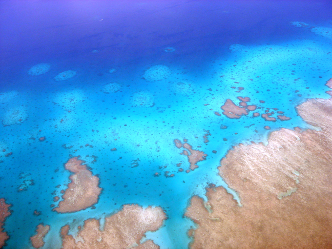 Inner reef structures of Mayotte, showing the complex formation of reef and sand habitats. Inner reef structures of Mayotte, showing the complex formation of reef and sand habitats.
© David Obura
|
Jurisdiction - Mayotte is a Département of France.
Description - Extensive geomorphological and biological studies of the Mayotte reef system reveal a detailed history of the island and reefs. Mayotte is formed by two shield volcanoes surrounded by a barrier reef system. The limestone coral reef began to build about 1.5 mya. The lagoon floor and the reef became emergent during the last Glacial Maximum 26,000 years ago when sea level was 100 m lower than today, at which time meandering channels formed in the lagoon floor and karst systems formed in the reef wall. The lagoon re-flooded 11,600 years ago. The current Holocene reefs grow on the ancient Pleistocene reefs.
The barrier reef is 220 km long with a variable width between 800 and 1500 m. It is not continuous, and in the north and west is submerged. The lagoon has an area of 1100 km², the largest in the region for a high volcanic island, and is up to 12 km wide and 80 m deep. Within the SW lagoon, an internal double barrier reef is present in several segments over a length of over 18 km, a unique feature in the Indian Ocean. Several other reef formations are present in the lagoon: pinnacles, inner reefs, patch reefs and fringing reefs on the island shores, with a total length of 160 km. To the north the Iris bank extends outside the barrier reef, at depths of 15-30 m.
Features of Potential Outstanding Universal Values
Criterion viii - Geology and oceanography
Geology: As part of the Comoros-Glorieuses crescent, Mayotte forms a unique series of island-bank formations combining hotspot and ancient fracture processes, and a boundary between basin features.
Oceanography: Mayotte and the banks may play a role in inducing and stabilizing the dominant anticyclonic flow of the NE corner of the Mozambique Channel, causing higher temperatures in this zone and a particular marine climate with implications on climate vulnerability of marine systems. |
Criterion x - Habitats and conservation
Diversity: In the center of the WIO center of diversity; unusually high species richness of many taxa for an island system: > 270 species of hard corals, 750 fishes and 455 crustaceans. Mayotte has the maximum hydroid species richness known in the region (173 species) and the Millepora family is also more diverse.
Turtles: Green turtles, up to 5000 nesting females a year; hawksbills: up to 100 nesting females a year.
Sharks and Ray: winter abundance of manta rays (Manta alfredi) and scalloped hammerhead sharks (Sphyrna lewini).
Marine mammals: high diversity of marine mammals; important humpback whale mother/calf nursing zone; south lagoon is known to be a breeding site for Megaptera and high diversity of cetaceans. Dugong present in the lagoon. The banks (Geyser, Zélée, Iris) and eastern region of the Comoros may be an important area for humpback whales during the late austral winter months. |
Criterion ix - Ecology, species and evolution
Coral reefs: the complex reef geomorphology, combined with the diverse eddy currents and oceanographic conditions in the region, contribute to high habitat diversity. Mayotte has the most complex reef geomorphology of all small islands in the WIO and the Mozambique Channel. Combined with high levels of connectivity and the importance of the channel regionally, it represents a critical refuge and stepping stone for dispersal and maintenance of reef diversity in the WIO. |
Threats - The Comoros is one of the least developed countries in the region, and population growth is leading to rapid increases in direct pressures on the sea for resources, principally food, and in land-based impacts such as pollution and sedimentation. Mayotte has a higher standard of living as its is a region of France, however higher consumption levels, land-based development and greater motorization of fisheries result in even greater threats to the marine environment. Fishing on the isolated banks (Geyser, Glorieuses) is a growing threat as depletion of fish on the main islands occurs, and increased nearshore management of fisheries pushes illegal fishers farther offshore. The islands are also in the center of highly active zone of oil and gas exploration driven by the neighbouring countries, so is highly vulnerable to impacts over which it has no control. The eastern parts of the Comoros and Mayotte lie in an apparently warmer zone in the northern Mozambique channel, raising the risk of thermal stress and coral bleaching.
The primary threat to coelecanths is renewed and increasing deep benthic fisheries, due to the need to feed the growing island populations.
Management status - The Tanga Coelecanth Marine Park (northern Tanzania), designated in 2010 specifically to protect the population of coelacanth being affected by fishing (37 individuals caught from 2003-2010) may be key to their survival, though further studies will be needed to determine its efficacy. The isolation of this sub-population suggests that separate actions for conservation of Mozambique channel coelacanth are necessary. The high degree of mixing in the channel presents a classic test case of whether to designate few large or many small protected areas. The existing World Heritage site at iSimangaliso is south of the geographic border of the channel, though is linked by currents moving southwards. However there may not be any return flow of genetic material back into the channel, reducing its role in protecting coelacanth over a broader geographic range. Thus key sites in northern Mozambique and Madagascar, the Comoros, and south Mozambique and Madagascar may be necessary. The Comoros is the dominant population known to date, so is the highest priority for coelacanth protection.
Coral reef, seagrass and mangrove conservation is of strong interest for local livelihoods and security, and biodiversity protection. The Moheli Marine Park protects the most complex and diverse reefs in the Comoros on the south coast of Moheli, but impacts from fishing and terrestrial runoff within the park are very high. In 2011 the entire EEZ of Mayotte was designated as a Marine Protected Area, though zoning is yet to be established. The island has had some small no-take areas established in recent years. In 2012 the entire EEZ of Glorieuses was also established as a Marine Protected Area, excluding fisheries.
Key References – Audru et al. (2010); Class et al. (1998); Emerick & Duncan 1982; Ersts et al. (2011); Esson et al. 1970; Fricke et al. (1998); Maugé et al. 1982; Nougier et al. 1986; Thomassin et al.
1989; Wickel et al. (2010). --> References
|
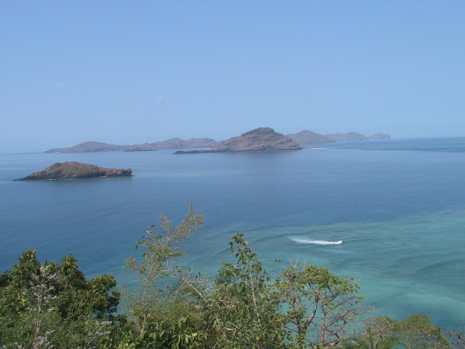
 The Comoro archipelago includes a full series of geomorphologies from the young active volcano (left, Ngazidja) to eroded slopes and isolated nearly-submerged peaks (middle, Moheli) to submerged atolls and banks (right, Geyser).
