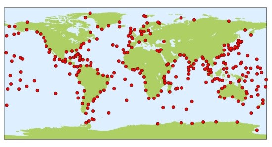
The Sea Level Station Monitoring Facility (SLSMF) provides a centralised platform for real-time sea level data from 1,251 monitoring stations worldwide, managed by 170 station operators. Hosted by the Flanders Marine Institute (VLIZ) in Belgium, this open-access service allows tsunami warning centers, researchers, policymakers, and the public to track sea levels in real-time. By offering crucial data for early warnings of sudden sea-level hazards such as tsunamis, SLSMF plays a vital role in disaster preparedness and global ocean monitoring efforts.
SLSMF launched in 2006 to address Africa’s lack of sea-level monitoring stations through the ODINAFRICA project. It was the first system to check the operational status of regional sea-level stations. Since then, it has expanded into a global network, connecting real-time sea-level stations across five continents.

Many of the 1,251 active stations that feed data into SLSMF are part of UNESCO’s Intergovernmental Oceanographic Commission (IOC) programmes, including the Global Sea Level Observing System Core Network and regional tsunami warning systems in the Indian Ocean (IOTWS), North-East Atlantic & Mediterranean (NEAMTWS), Pacific (PTWS), and Caribbean (CARIBE-EWS). Others contribute to the Global Sea Level Observing System (GLOSS) core stations, providing long-term quality-controlled sea level data at hourly, daily, monthly, and yearly intervals. Key institutions such as the Permanent Service for Mean Sea Level (PSMSL), the British Oceanographic Data Centre (BODC), and the University of Hawaii Sea Level Center (UHSLC) further process and control the data, so scientists involved with sea level research can analyse the data and calculate long-term trends. In 2024, a system for the automatic quality control of real-time data was implemented, enabling researchers to utilise the data immediately. From the above-mentioned datacentres, data is also flowing to the European Marine Observation and Data Network (EMODnet).
Beyond monitoring, the collaboration with UNESCO-IOC and the VLIZ team at the SLSMF actively supports capacity building and knowledge exchange. In 2022, it co-organised a training course titled “Sea Level Data Sharing: Tools for an Effective Regional Emergency Response” in collaboration the Chilean Navy’s Hydrographic and Oceanographic Service (SHOA), with the participation of regional partners in the SE Pacific (Colombia, Ecuador, Peru).
In 2024, the SLSMF was officially endorsed as an Ocean Decade Project under the Ocean Decade Tsunami Programme. As part of this commitment, SLSMF aims to increase the use of ocean knowledge. By delivering quality-controlled data to all National Tsunami Warning Centres (NTWCs) and Regional Tsunami Service Providers (TSPs), it supports the expansion of observational systems, and it strengthens monitoring in Tsunami Risk Zones, particularly in Least Developed Countries and Small Island Developing States. This high-quality data will help users to identify vulnerable places for sea-level hazards and improve tsunami detection accuracy, as was the case for the Tonga Tsunami in January 2022. An eruption of the underwater volcano Hunga Tonga-Hunga Ha'apai, near the Kingdom of Tonga in the Pacific Ocean, triggered a tsunami as high as 15 metres that struck the Tonga archipelago. Using tide gauges from the Sea Level Station Monitoring Facility, it was possible to track how the tsunami raced across the Pacific Ocean, with waves reaching up to two metres in the Indian, Caribbean, and Atlantic Ocean.
Looking ahead, the UN Ocean Decade endorsement ensures the SLSMF will continue expanding its network and integrating new sea-level monitoring stations, safeguarding long-term support for global and regional early warning systems beyond 2030.