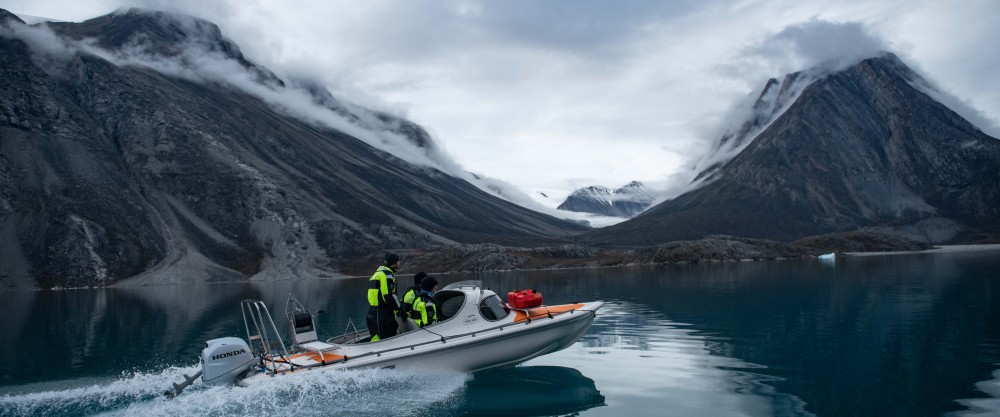
For nine days in September 2023, researchers observed an unprecedented seismic signal. The cause of this mysterious ‘earth tremor’ turned out to be a giant landslide in Greenland: a mass of 25 million m3 of rock and ice came loose and thundered into the Dickson Fjord. This created a 200 metre high megatsunami that kept sloshing back and forth in the narrow fjord for nine days, a phenomenon known as ‘seiche’. That is the conclusion of research published in the leading journal Science. This movement of a large mass of water caused vibrations throughout the Earth, shaking the planet and measuring seismic waves observed worldwide. Never before, scientists – including researchers from the Royal Observatory of Belgium, the Falanders marine Institute (VLIZ) and the Université libre de Bruxelles (ULB), observed such an unusual mechanism causing a global seismic signal.

September 2023. Globally, seismologists observe see to their great surprise a mysterious signal – from North to South Pole – on their highly sensitive measuring devices, that lasts for nine days. The signal looks nothing like that of an earthquake, but rather sounds like a monotonous hum. At the same time, a team of scientists working in remote northeastern Greenland learns that a major tsunami has occurred there. The news spreads, the teams decide to work together and soon a unique multidisciplinary group of 68 researchers from 40 institutes and 15 countries forms (including the Royal Observatory of Belgium (ROB), the Flanders Marine Institute (VLIZ) and the Université libre de Bruxelles (ULB)). They combine seismic data and infrasonic sound data, with field measurements and images, satellite recordings and simulations of tsunami waves. Photographs taken by the Danish army a few days after the event also turn out to be of golden value. They show the collapsed mountain wall and glacier front, in addition to the damage caused by the tsunami in the landscape. The combination of field data at the site and globally observed signals allows the researchers to explain the extraordinary event in September 2023 and publish it today in the renowned journal Science.
The local signal was picked up by a real-time monitoring network set up in the Kong Oscar Fjord System (including cameras and oceanographic monitoring points) in summer 2023. Oceanographic sensors showed anomalous water levels and very high turbidity in the fjord. At the same time, a global network of sensitive seismometers recorded a planetary signal, resulting from vibrations travelling through the ground – called seismic waves. Traditionally, seismology focuses on measuring seismic vibrations resulting from earthquakes in the ground. However, seismic data can also contain information about movements of large masses on the earth's surface, such as landslides and water waves. The study found that the landslide was the result of the collapse of a mountain peak that previously towered 1200 m above the fjord. The amount of material that collapsed was huge – more than 25 million cubic metres – or 27 times the volume of all the containers on the world's largest container ships. The cause of this collapse is the thinning of the glaciers at the foot of the mountain in recent decades, ultimately caused by climate change.

Photos of the mountain peak and glacier as seen from the fjord. Left: before the event in August 2023. Right: after the event in September 2023.
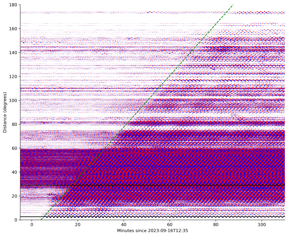
The seismic signal was so intriguing that one of the researchers tried to mimic the long sustained and back and forth sloshing water movement in the fjord, in his bath. Which failed. Mathematical models, on the other hand, were able to show that the orientation of the landslide determined the effect. The fact that the slip took place via a glacier, perpendicular to a remarkably narrow and curved fjord, proved to be the missing piece of the puzzle to explain how climate change could shake the earth for nine days. Indeed, model calculations show how the water in the fjord should be sloshing back and forth every 90 seconds, just as in the actual observed pattern of seismic waves. This perfect match shows how the force of a mass of water, rushing into a fjord of a certain width and depth, can generate a visible vibration of seismic energy in the earth's crust.
Coauthor Thomas Lecocq (Royal Observatory of Belgium) concurs: ‘Our initial estimates of the source's position concentrated on East Greenland. At the same time, Greenlandic and Danish authorities received reports of a large tsunami at the (then unmanned) Nanok station and research base on Ella Island. As an interdisciplinary and international research team, we integrated all the information to present a detailed reconstruction of the first documented large tsunami-induced landslide for East Greenland and how it generated global seismic signals with a very long period. It is amazing that what started as a routine check of a Belgian gravity sensor turned into a global, multidisciplinary collaboration, with virtual, online exchanges for 24 hours a day, across many time zones. I am happy that we proved that the source of the vibrations was the sloshing of water, and that this adventure led to new collaborations with colleagues around the world. Including Wieter Boone from VLIZ who is installing KSB seismic instruments in Dickson Fjord this summer to further enhance our understanding of this unique area.’

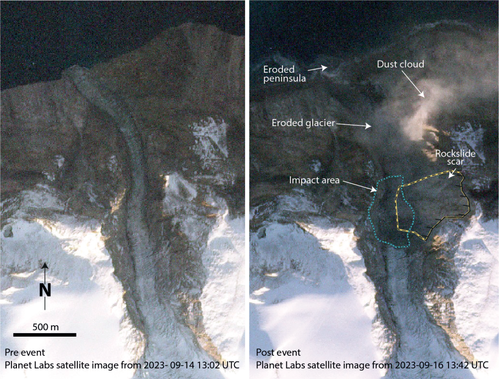
Satellite images of the fjord. Left: 30 minutes before the landslide. Right: 7 minutes after the landslide.
A combination of numerical simulations, data from the local oceanographic sensor network, and satellite and ground images confirm that the landslide-induced mega-tsunami must be one of the very highest ever measured. Seventy kilometres further down the fjord, the still 4-metre-high waves caused damage to the station on Ella Ø and destroyed cultural and archaeological heritage sites. The fjord is also very popular with cruise ships visiting the Greenland fjords. Fortunately, there were no ships around that day of the landslide and tsunami. Otherwise, the consequences of the huge tsunami wave would have been incalculable. In times of accelerated climate change, it will be more important than ever to better understand and monitor these kinds of areas, hitherto considered stable. Developing ‘early warning’ tools for these kinds of large landslides and tsunamis is part of this.
Co-author Wieter Boone (Flanders Marine Institute): ‘For our research, we set up a network of real-time oceanographic stations in northeast Greenland. Last year, we sailed through Dickson Fjord to install instruments close to a glacier and almost right in front of the mountain, just weeks before it collapsed. Our instruments survived the tsunami and we were able to monitor events in real time. The observed destruction of an ancient trapper's hut, which had never been hit by tsunamis in its centuries-long history, shows the unexpected scale of this event. During the investigation into the cause, an exceptionally dynamic and international collaboration emerged in which the team from KSB, played an impressive role. This summer we were back in the area. We updated our sensor network, mapped the impact of the tsunami using drones and installed high-frequency seismic and water level sensors in Dickson Fjord.’

Section of observed seismic waves plotted against the distance to the landslide (1 degree = 110 km; 180 degrees = antipodal to Greenland). The sloshing of the water mass in red (positive amplitude) and blue (negative amplitude).
Svennevig et al. (2024). A rockslide-generated tsunami in a Greenland fjord rang Earth for 9 days. Science, 385 (6714).
- Read the article in Science
- Download the pdf in the Open Marine Archive of the VLIZ library


